Walker Ranch/Eldorado Canyon Fire
(for residents west of Gross Reservoir in Magnolia/PUMA area)
Last updated: Tuesday, 19 September 2000, 7:30 am MDT (final, barring unforeseen
circumstances)
This site has been maintained during the fire by: Clark and Lynda Chapman
(cchapman@boulder.swri.edu;
ychapman@rmi.net)
These updates have been based on reports from various people and information sources
and are
not guaranteed to be accurate; please e-mail us any important info you may have. The
infrequently updated source for official
information is an emergency recording for affected residents set up by the Boulder County
Sheriff: 303-441-4300 (you often get a busy signal so keep trying). Eldorado Incident
Command Post information is occasionally posted to: www.ci.boulder.co.us.
FINAL UPDATE, 8:30 PM MONDAY EVENING
Good news! The danger is not totally gone, but the probability is good that the
Eldorado Fire will not rekindle in a dangerous fashion. The Boulder County Sheriff
reports the fire is 60% contained and that conditions are favorable for achieving full
containment soon, perhaps by Tuesday evening. Evacuated residents are, in a restricted
fashion, being allowed to
return...although their power will remain out for at least three more days. There was no
mention, in the latest report, of the standby status for Magnolia residents.
There will be a public hearing tomorrow (Tuesday the 19th) at Baseline Middle
School, 700 20th St., to hear from affected residents (including us). It will begin at 4 pm
in the school
auditorium. (Or -- exemplifying continued official confusion -- the official city web
site still says Tuesday morning
that the hearing will be held in the Boulder County Commissioners Hearing Room in the
County Courthouse. We presume that Tuesday morning's Camera is correct and
that the meeting is at the Middle School. Phone 303-441-4300 Tuesday
morning and maybe they'll have the correct info.) We won't be able to attend the
meeting, but there are questions that might be asked:
(1) Why has there been such inconsistent and irregular communication from official
sources, right up to the end? (2) Why (as we've been told) were local firefighters ordered
by just-flown-in federal managers to "stand by" during the height of the fire emergency
late Sunday? (3) Why did they run out of slurry just as flames were encroaching on
neighborhoods? (4) If the news media are in attendance, they could be asked about
their generally minimal and unreliable coverage of this threatening story during the past
three days.
The Boulder County emergency recording notes that a "limited" fire danger still
exists...and that is true. Winds are still forecast to pick up and change direction later in the
week. The embers will burn for days, like a thousand untended campfires. It will require
aggressive vigilance on the part of fire personnel and good fortune from Mother Nature to
ensure that this fire doesn't escape again and threaten us all.
This will be our final update, barring unforeseen developments. We appreciate the
thanks we have received from several neighbors.
MONDAY LATE-AFTERNOON UPDATE
At this time yesterday, there was a towering plume of smoke and flames were
jumping the fire lines. Today, no smoke plume is visible at all from several directions.
However, those with a clear view down to the north from Coal Creek Canyon can see
spotty sources of smoke and occasional torching trees...being worked by aircraft. While
the fire is not actively moving, an increase in the winds could quickly renew the ominous
movement of the fire. Officially, as of 3:30 pm, the fire was still wholly uncontained and
"out-of-control," and conditions were being described as "extreme." All evacuations (and
standby advisories) remain in effect. The map below has been updated with the
"official" boundaries of the burned area.
The latest weather forecast indicates that winds will pick up, from the west and
northwest, late Monday night and continue gusty through Tuesday evening. Tuesday night
and Wednesday morning a dramatic shift in direction (upslope winds from the northeast) is
possible. Windy conditions are forecast through Friday, although temperatures will drop
with snow possible by Saturday morning.
MID-MONDAY MORNING UPDATE
The fire has grown to nearly 1100 acres (we're unsure in what direction relative to
the orange area depicted on our map below, updated last evening). [9 a.m. update: the
larger estimated size of the burned area is now reported to be due to improved estimates,
not due to significant overnight spread of the fire. The fire is said to be growing
"slowly". At 10:30 a.m., the Sheriff reported that the fire was "laying down, with no
significant movement."] No homes were
reported destroyed yet as of early this morning, with Lake Shore and Pine Needle Notch
subdivisions in most serious danger; protecting them will be the highest priority today.
Moderate westerly winds, on the surface and ground, should
push the fire northeastward toward Boulder today. The weather forecast hasn't changed
much: cooler with small chances of showers and lightning and somewhat blustery breezes
over next few days, with possibilities of upslope breezes and showers Wednesday
morning...maybe snow by the end of the week.
Early this morning, the Sheriff's phone number described the precautionary evacuation
readiness alert
west of the reservoir as applying to "within 2 miles radius of Gross Dam." Taken literally,
this applies to only a very few homes in the Magnolia area: near Road 68J and at the
southeastern end of Twin Sisters Rd. (Most homes in the Magnolia area are at least 1.5
miles still farther away.) We do not believe, however, that this reflects a conscious change
from yesterday's reverse-911 announcement and associated Sheriff's statements...it is
probably only continuing inconsistencies in official announcements. [The 7:30 and 10:30
a.m. Sheriff's report refers to 6000 - 9000 numbers along Magnolia, although the reverse-
911 phone calls yesterday afternoon referred to 4000 - 9000.]
SUNDAY LATE EVENING UPDATE
About 5 pm, residents in the Magnolia area (west of either the 4 or 6
mile markers [official notices are inconsistent] to the Lazy Z intersection) were advised by
reverse-911 phone calls to begin preparing for evacuation. This is advisory; residents are
NOT advised to actually evacuate. This advisory presumably applies to all
residents living east of Magnolia, as well: along Twin Sisters, Rd. 68, Aspen Meadows,
Pine Glade, Forsythe, and Lazy Z. This advisory status is the same one that residents of
subdivisions northeast of Coal Creek Canyon Rd. (Rte. 72) have been living with for two
days. Power was out for a while in the Magnolia area this afternoon; similar periodic
power outages have occurred in Coal Creek Canyon neighborhoods -- possibly a way of
warning residents but without permanent loss of power.
If evacuation becomes necessary, the official meeting site for evacuees has been
changed to 777 Broadway in Boulder.
As shown (approximately) in the orange area of our updated map below, the fire has
burned nearly a mile to the northwest along the northeast shore of Gross Reservoir toward
the Lake Shore subdivision. The Sheriff reports, however, there are still no structures lost
as of 8:15 pm. Despite prevailing southwesterly winds much of the day, there was
apparently a low level upslope breeze that pushed the fire seemingly upwind. The gusty
winds, predicted to continue tomorrow, blew the fire (once declared 20% contained earlier
Sunday) wholly out-of-control again. The fire has apparently crossed both Flagstaff and
Gross Dam Roads, which are closed until further notice. Observers from high ground
south of the fire report that there were almost no large-plane slurry drops today (have they
run out of slurry? [Yes, they did run out Saturday night, according to the Monday
morning Denver Post]).
The latest weather and fire-weather forecasts are a mixed blessing. On the positive
side, temperatures will be much cooler and there are chances of showers the next several
days; on the down side, winds will initially be gusty and there are chances of lightning the
next several days.
EARLIER NEWS IS REPORTED BELOW
Numbers for the Boulder County Sheriff's emergency recording and web sites are given.
SUNDAY NOON UPDATE
An hour ago, the Weather Bureau updated the forecast for Nederland and the
foothills to call for gusty winds beginning this afternoon. The smoke plume has started to
rise from convection. Although the Sheriff's Dept. has not yet updated their 8:30 a.m.
report that the fire was still at 600 acres and only 10% contained, much will depend on the
weather as a front moves through tonight. The good news is that it will get cooler with
possibly a shower. Lightning is possible but unlikely. The big potential problem is winds.
Note that our map has been updated, although the area of the fire is still very approximate.
SUNDAY MORNING UPDATE
The fire apparently has not expanded too much overnight. Finally, it is gaining
national attention. Not only has the fire made the national news, but it has now been
placed under federal management at second-from-top priority. There is no change to the
weather forecast described in the first report below. Smoke has still not started to convect
upwards as of 8:30 a.m. Sunday.
Of potential concern to some folks living west of the fire is a report in one of the
morning newspapers that a natural gas line lies near the ground under the vicinity of the
fire; the supply may be turned off. There is finally some reasonable coverage on the major
news media web sites. A map in this morning's Post shows the fire located roughly where
we've shown it in the map below, but stretched a little farther both east and west.
11:30 PM SAT. UPDATE
Neither the Sheriff's emergency phone number (see below) nor the media web-sites
(e.g. the two Denver papers, the Boulder paper, Channels 7 and 9) are providing much
new. More precautionary evacuations have apparently been ordered in Coal Creek
Canyon. The smoke appears to be settling onto the ground, as it did last night, and the
winds are calm, so there is little reason for immediate concern.
REPORT AS OF 6:30 PM, SATURDAY
The news media folks are home for the weekend, so there is little info available.
Here's a bit. For brief news, the Boulder County Sheriff's number (303-441-4300) has
been updated during Saturday about every 3 hours. Subdivisions east and north of Gross
Reservoir have been evacuated; those northeast of Rte 72 in Coal Creek Canyon have been
put on alert for evacuation. The reason for the alert is said NOT to be because the homes
are in imminent danger but because there are such limited evacuation routes.
The fire was reported at around 400 acres late last night, and about 600 acres late
Saturday afternoon. We've heard reports that it has expanded in all directions, but
preferentially to the north and west. That is because, during the daytime, there is a
tendency for winds to blow upslope. As they did last night, expect the winds to blow the
smoke down into Boulder overnight until about 9 a.m. tomorrow. There will be upslope
winds again Sunday mid-day, but a chance that stronger southwesterly winds will reach
surface levels by tomorrow afternoon. This will keep the fire from coming towards the
Magnolia area, but will be troublesome for firefighters if the fire is still burning.
The most complete news coverage (but updated only every 6 to 12 hours or so) has
been the Daily Camera:
www.thedailycamera.com.
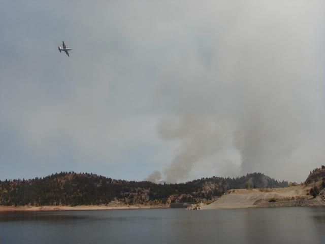
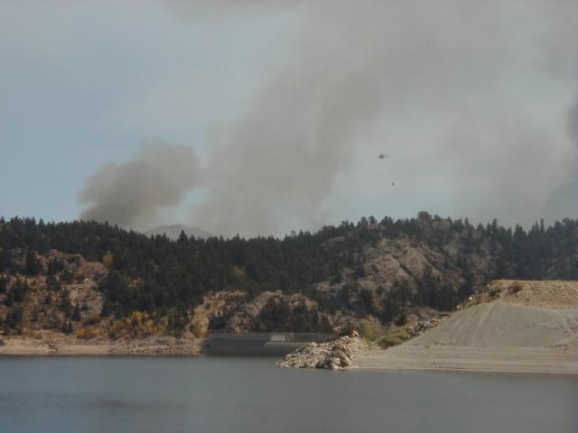
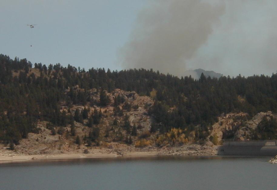
We took a couple of photos Saturday morning from our place at the east end of
Lazy Z, then went to the peninsula (end of Forest Rd. 359) on the western shore of Gross
Reservoir for the rest of these pictures. They show slurry bombers circling the smoke, still
on the other side of the ridge beyond the dam at 2 pm, and a helicopter scooping up water
from the reservoir.
MAP OF WALKER RANCH FIRE ZONE AND NEIGHBORHOODS TO THE
WEST
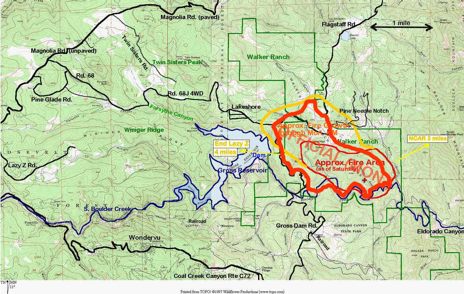
The fire reportedly started (Friday, 2 pm) somewhere near Kentucky Gulch as indicated by
the cross, north of South
Boulder Creek within the Walker Ranch trail loop. The 600 acres said to have been
burned by Sunday morning are about
one square mile, centered somewhat northwest of the starting location (red ellipse).
The fire extended by Sunday
evening to over 800 acres, later estimated at 1100 acres, apparently primarily north and
west, as shown (again, very
approximately) by the yellow-orange-bounded area on the map. An official map showing
the boundaries of the burned area as of Monday morning has been released (see below);
we show those boundaries here with a thick red-orange border.
For scale, note that the approximately
rectangular grid of thin brown lines denotes square miles. Thus, for example, residences
along Pine Glade Rd. are 3 to 3.5 miles west of the Lakeshore subdivision and about 4
miles from Gross Dam on the eastern edge of the Reservoir.
An official map of the fire boundaries was available Monday afternoon: Official Fire
Map.
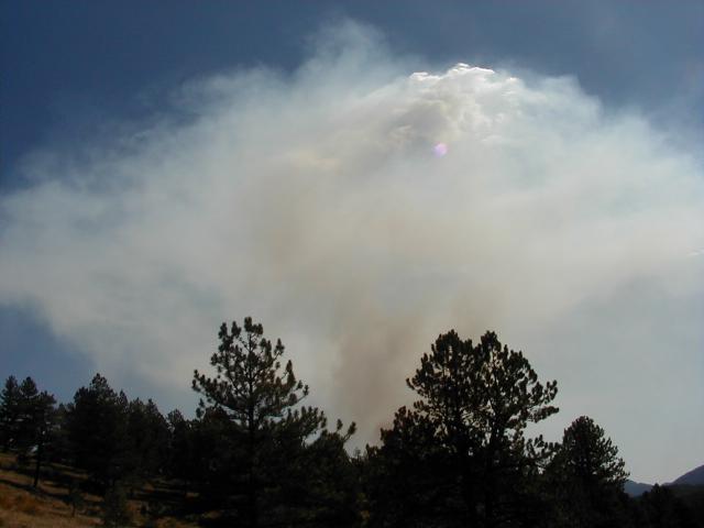
PHOTOS TAKEN SUNDAY LATE AFTERNOON FROM WEST OF
MAGNOLIA
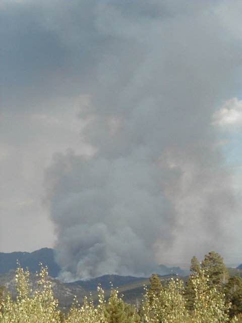
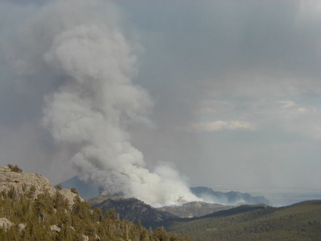
PHOTOS TAKEN SATURDAY AFTERNOON FROM WEST SIDE OF
RESERVOIR
